The Wide Missouri
The Wide Missouri
| Oh, Shenandoah, I long to hear you, Away, you rolling river. Oh, Shenandoah, I long to hear you, Away, I'm bound away, 'cross the wide Missouri. |
In December 1803, at the direction of President Thomas Jefferson, Meriwether Lewis and William Clark arrived on the banks of the Mississippi River across from St. Louis and on the very edge of the Louisiana Purchase, one of the most extraordinary peaceful transfers of geographic sovereignty in the history of the world. The story of that epic journey and all that was discovered has been well reported elsewhere, and in this first year of the bicentennial celebrations much may be found on the web, including a detailed chronology.
The Missouri River provided Lewis & Clark a convenient and for the most part easy highway to the west. In years following the expedition, for the many communities that developed along its banks, the river was transportation but also an obstacle to points farther west. (Unsurprisingly, at least in the Dakotas, the larger communities are inevitably found on the river's eastern shore -- e.g., Pierre and Bismarck.) Even today bridging the river is a non-trivial matter, so one can travel for miles and miles along its banks unable to cross. I undertook my small trip to the Missouri not so much to replicate coincidentally Lewis & Clark's journey, but instead to record the places and ways that the river has in fact been bridged, and capture artistic photos along the drive.
I've provided a map to show locations of the trip's photos, which will open in a separate window. Begin at the map's lower right-hand corner; the route driven is marked by a blue line. To view the route, click
(The following photos appear in chronological order, so for those whose descriptions give no map location, they were taken along the drive between adjacent map numbers.)
|
|
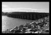
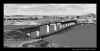
Chamberlain,
South Dakota [map location 1]. From Minneapolis I drove southwest
to I-90 as it crosses southern Minnesota, and then west on the interstate to Chamberlain,
where it crosses the Missouri. For a modest hamlet, Chamberlain has an astonishing
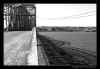
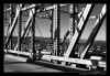
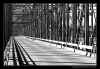
three bridges. First at the left is a panorama taken from higher on the river's
banks, showing the railway bridge at left and the I-90 bridge at right. (The two
interstate bridges seen on this trip were boring!) Then comes another panorama taken
from the water's edge, with the older Chamberlain bridge seen in the distance to the north
(right). Three black and white detail views of the Chamberlain bridge itself follow. I love the erector set look to these older bridges -- so much more interesting than the antiseptic reinforced concrete structures erected in the last half century. |
|
|
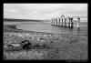
Big Bend Dam at the foot of Lake Sharpe [map location 2]. (Taken below the dam from the Missouri's west bank. Unless so noted, all photographs are taken from the east bank.) The dam is located in the Crow Creek Indian Reservation, which itself is close enough to I-90 that it has a fairly busy casino in Fort Thompson, right next to the dam. |
 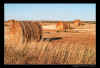 |
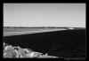
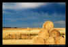
Driving the northern Great Plains, one cannot avoid scenes of panoramic splendor and agricultural activity. The first photo is Midwest minimalism in the style of Michael Kenna, a photographer whose work I greatly admire. Since my drive was in late September, harvest was nearly finished, and the last gigantic cylinders of hay lay on fields awaiting winter's snows or to be hauled off as fodder nearer the farmer's livestock. The lowering sun gave the fields the aura of deep gold. |
|
After staying overnight in Pierre, SD (pronounced "peer"), I rose early enough to catch the two bridges lit by the rising sun, first the auto bridge for US Routes 14 and 83 and SD Route 34 [map location 3]. Again, the older railroad bridge is more interesting. |
|
Lake
Oahe (pronounced "oh-WAH-he") [map location 4] is the first of
the major lakes formed by waters backed up behind dams on the Missouri, at least if one
travels upstreams. Needless to say, these dams also have destroyed appearance of
the river and its surroundings as seen by Lewis & Clark, although their salutary
effects (irrigation, flood control, power generation, etc.) far outweigh that impact on
history and geography. Lake Oahe Dam was also where I first began driving SD Rte 1804. The route number intrigued me at first, since I did not understand why they would use "1804" in a state like South Dakota where two digits surely would suffice to designate a road. Also curious was the fact that the route number continued into North Dakota. Then I realized: Lewis & Clark traveled up this portion of the Missouri in the year 1804 (Rte 1806 lay on the west bank of the river, which was the year they returned down the Missouri). Lake Oahe stretches almost to the Bismarck, ND, city limits. |
  |
More scenes from farmland along the river. |
| US Rte 212 bridge [map location 5]. A beautiful structure crossing Lake Oahe. | |
 |
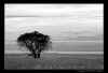
Trees in a gully, showing how they seek locations of maximum ground moisture, and why trees standing in the middle of the Great Plains are so rare. |
|
Railroad and US Rte 12 auto bridges at Mobridge, SD [map location 6]. Get it? "Mobridge" -- "Missouri Bridge." The US 212 and US 12 bridges are structurally almost identical. |
| A cornfield panorama. If anyone doubts the Midwest's role as breadbasket (or in the case of corn, I suppose "cereal bowl") to the world, one need only see these immense expanses of grain. | |
|
Bridges in Bismarck, ND [map location 7]. In order from the top: 1) Railroad bridge (looking south); 2) Interstate 94 bridge (looking north); Memorial Bridge (looking south); Bismarck Expressway Bridge (looking north); and Memorial Bridge again (looking north). |
| ND Rte 200A bridge [map location 8]. | |
|
Garrison Dam, behind which lies Lake Sakakawea [map location 9]. Garrison Dam is one of the largest earthen dams in the world. Photos are 1) view of the dam looking downriver, with surge tanks in the foreground and turbine house just beyond (taken from the western shore); 2) Lake Sakakawea from the eastern shore; and 3) the spillway gates, looking toward the eastern shore (looking east, however). |
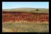 |
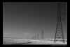
Autumn colors of the prairie. Another notable feature of the prairie north of Lake Sakakawea were the occasional fenced enclosures designated by names such as "E-3" or "H-6." They stand as a poignant if lonely reminder of the Cold War -- decommissioned Minuteman nuclear missile silos. Of those I took no photos. |
|
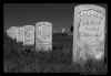
Driving along the north shore of Lake Sakakawea, just after entering the Fort Berthold Indian Reservation, I chanced upon this cemetery sitting totally isolated by the side of the road: "Indian Scout Post No. 1" [map location 10]. It seemed worth investigating. Headstones along the left edge (in the panorama) are recent, for tribal members who had served in the U.S. armed services in recent wars, but the center headstones simply noted that the person buried had been an "Indian Scout, U.S. Army" and giving the English versions of their names, such as "Lean Bear" or "Walks the Flats" as seen in the second photo. |
|
|
Again a panorama showing the immensity of wheatfields stretching to the horizon on the northern plains. The wheat has been harvested in this photo which looks north towards the Canadian border. |
|
Four
Bears Bridge (ND Rte 23) across narrows on Lake Sakakawea [map location 11].
(The panorama is taken from the western shore.) According to one reference, the
center span of this bridge had originally been located 35 miles west of Garrison, ND, near
the small town of Elbowoods within the Fort Berthold Reservation. Both bridge and
town locations, however, were submerged with the rising of Lake Sakakawea behind Garrison
Dam, with the population relocated to New Town (just to the east of the present bridge)
and the bridge itself, I presume, floated up the lake to become part of this newer
structure. A replacement bridge is being built just north of the present structure. The replacement is probably much needed, as the present roadway is very narrow, but design illustrations of the new structure show a typical if elegant reinforced concrete span, and we no doubt will lose another of the grand old steel bridges like others seen in these photos. |
|
US
Rte 85 bridge [map location 12] (taken from the south bank looking
upriver). A modern bridge just south of Williston, ND, and the final photo from
this trip. A Bridge Too Far One additional bridge spans the Missouri within North Dakota: that near Buford and the Montana border, just beyond the juncture of the Missouri and the Yellowstone River, at the end of Rte 1804. I reached that bridge but found no access on either shore providing an easy location to photograph the structure. It was mid-afternoon, and I did not feel much like forcing my way through thick undergrowth. So that bridge is missing from this documentary, perhaps to be captured when I return next to the area. As for this trip, I set out from this point in far northwestern North Dakota and drove straight through to the Twin Cities, arriving home about 1:15 a.m. Total distance for the trip: over 1,600 miles in three days. I have never driven so many miles over two lane roads in my life. |